Geocaching is a race without competitors, a treasure hunt without much treasure. Follow me as I explain what Geocaching is as well as a brief history of Global Positioning Systems (GPS). As a hobby Geocaching leverages the availability of cheap GPS devices able to display your latitude, longitude and altitude, together with geeky clues to guide you to a hidden stash.

A Brief History Of GPS
We take the availability of Global Positioning Systems (GPS) for granted as a ‘free’ service. But this constellation of more than two dozen satellites has been available to the public for less than 20 years, and has operated at the current degree of accuracy for just over a decade.
Indeed, if the passenger jet Korean Air Flight 007 hadn’t suffered navigation difficulties which led to it being shot down by the Soviet Union after accidentally crossing into their airspace, we might never have had free GPS capability made available to the public (see p248 of PDF “GPS History, Chronology, and Budgets” by Rand Corporation).
When the US Military NAVSTAR (Navigation System for Timing and Ranging) GPS system was opened up in the early 1990s to prevent such a tragedy from reoccurring, it also enabled all kinds of business and personal uses for location-based data.

GPS devices really took off in popularity after May 2000, when the US military implemented President Clinton’s order to remove “selective availability” – which was really a deliberate lack of accuracy on the GPS signals used by civilians. This improved location accuracy from about 100 metres to about 20 metres. Advanced GPS devices can now pinpoint your location to within less than a metre.
More recently smartphones such as the Apple iPhone 4S and Samsung Galaxy S III as well as other GPS devices have been released with the capability to use signals from US GPS satellites as well as Russia’s constellation of GLONASS satellites, which provides better redundancy.
I write short articles as well as long feature “explainer” articles on topics including: Google Android Smartphones and Tablets, National Broadband Network (NBN), Space, Civil & Military Aviation, Ebooks and the Publishing Industry, Electric cars, Technology augmenting human capabilities etc for Geare Magazine. The editor of GEARE has kindly permitted me to post articles here after the magazine issue the article was printed in has passed its shelf life. I have added updates where new information is relevant.
How Geocaching Works
The community-operated site Geocaching Australia describes the process of participants deciding which nearby cache to look for and what happens if they succeed.
“What do they find? More often than not, a lunch box containing a log book, maybe some swappable goodies, and a pencil. Geocachers write a log in the book about their hunt, they may swap something they have for something in the box, always making sure their swap is fair, and replace the container exactly as they found it. The containers vary and may be as small as a film canister, as large as a 44-gallon drum.”
Unlike an old-fashioned pirate’s buried treasure, the benefits gained by geocachers are mainly the thrill of the chase, the enjoyment of solving cryptic clues about the place a cache is hidden, and the benefits of some good ol’ exercise in the outdoors.
What sort of clues? The archetype is perhaps the riddle encountered by the Fellowship in The Lord of the Rings at the entrance to the mines of Moria. This reads:
“The Doors of Durin – Lord of Moria. Speak friend and enter.”
“Oh, it’s quite simple,” says Gandalf. If you are a friend, you speak the password, and the doors will open.”
But of course Gandalf is flummoxed as he mumbles through a list of possible passwords like some amateur Middle Earth hacker, until Frodo breaks the riddle.
“Speak ‘friend’ and enter. What’s the Elvish word for friend?”
Gandalf says “Mellon”, and the door immediately opens. Which just goes to prove the perils of poor punctuation in runic syntax 🙂
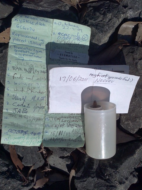
I embarked on a geocaching hunt in Sydney’s Inner West, looking for geocache ID GCGV74, called ‘The Bridge Walk’, with location details of S 33° 52.505 E 151° 09 and a riddle clue:
“This bridge is near a bay but not the harbour. This bridge crosses a steady stream but not of water. The cache is near the path of the silver snakes.”
In this case I found the cache next to a pedestrian bridge over the CityWestLink highway. The “steady stream” in the clue was the traffic, and the silver snakes were the vehicles that pass by. A picture of the ‘treasure’ is shown below.
Geocaching equipment
At the basic level, all you need to start geocache hunting is a handheld GPS device that has decent battery life and which can survive the outdoor weather when you’re tracking down a cache. And of course it needs to be a device that allows you to enter waypoint coordinates.
Most smartphones will qualify on these points so long as they have GPS functionality. You may need to enable the GPS (which is often off to save power), and to download a suitable app, such as the official “Geocaching” iPhone app ($) or the “c:geo – opensource” Android app (free). Remember, however, that GPS uses up a smartphone’s battery quite quickly if used heavily for several hours.
I tested Magellan’s high-end dedicated eXplorist 610 GPS device to find geocaches. It is loaded with oodles of features and is an impressive enough piece of tech, but I couldn’t help feeling much of it (and certainly the $699 RRP) was overkill for a hobby that is supposed to be simple, and that should require little expense.
Magellen also has the $239 Magellan eXplorist GC which still satisfies the key requirements of geocaching through its 3-metre to 5-metre accuracy SiRFstarIII-based 20-channel GPS receiver, a case usefully waterproofed to IP-X7, and the promise of up to 18 hours battery life. But however you search, always replace the treasure for the next geocacher in line.
This article was originally published in GEARE Magazine issue #69. It is “digitally reprinted” here with permission from the editor. I have added updates where new information is relevant.


Leave a Reply